Skype: neodalle-travel
Tel: +86 135 7447 2266
E-mail: sales@zhangjiajieholiday.com
 Shaanxi Province can be divided into northern, central and southern parts, differing in geographical, historical, cultural and climatic backgrounds, etc.
Northern Shaanxi
Located to the north of the Beishan Mountains, Northern Shaanxi mainly consists of the Loess Plateau and Maowusu Desert and has a temperate subarid climate. It was an important frontier stronghold in ancient times as well as one of the country's sacred places of the modern-day revolution. It boasts historical relics like Zhenbeitai of the Great Wall and revolutionary relics like the Site of the Former Offices of the CCP Central Committee -Yangjialing. The famous cities here are Yulin and Yan'an.
 Central Shaanxi
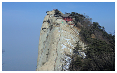
Central Shaanxi, or Guanzhong, is located to the south of the Beishan Mountains and north of the Qinling Mountains. It enjoys a temperate monsoon climate. Most of its landforms are plains and terraces. This is a place of deep national culture and rich historical relics, especially the ‘living history museum’, Xian itself. Exhibited in this 'museum' are various cultural relics like the eighth miracle of human beings, the Terracotta Warriors and Horses of the Qin Dynasty; China’s largest and best-preserved ancient City Wall; Drum Tower; Bell Tower; Big Wild Goose Pagoda and Qianling Mausoleum, the joint burial mausoleum of the country's first and only Empress, Wu Zetian and her husband Emperor Gao Zong of the Tang Dynasty. Even natural scenic spots like Mt. Huashan and Mt. Lishan here have some fairy tales and historical stories behind them. Xian is also the eastern terminus of the ancient Silk Road, a road connecting China and the outside world in ancient times.
 Southern Shaanxi
Southern Shaanxi refers to the region south of the Qinling Mountains, which belongs to subtropical monsoon climate zone. Covered by mountains, valleys and plains, this region has beautiful natural scenery such as Nangong Mountain National Forest Park, Zhashui Cave and Yinghu Lake. As a part of the Kingdom of Shu during the Three Kingdoms Period (220 - 280), the central and western parts of the region were greatly influenced by Shu culture, hence boasting relics related to Shu, such as the Wuhou Memorial Temple and the Ancient Plank Road. Controlled by the Qin and Chu States in the Spring and Autumn and Warring States Period (770 BC - 221 BC), its eastern part belongs to the Qin and Chu culture zone.
Aerial Shot Shows Loess Plateau's Gullies and Vitality in Shaanxi Province. Qingyang County is the biggest exploration base for oil and gas in Shaanxi, Gansu and Ningxia provinces.
 Loess Plateau in Qingcheng County of Qingyang in Gansu Province shows its numerous gullies and exuberant vitality from an aerial shot in early August. Qingcheng County is the birthplace of the Chinese nation and the center of Loess Plateau, where the soft loess layer is over 100 meters thick with uniform texture.The geography of the area is described as being part of the Ordos Desert in the north along the border with Inner Mongolia, the Loess Plateau in the central part of the province, the Qinling Mountains running east to west in the south central part, and subtropical climate south of the Qinling Mountains. In between the Loess Plateau and the Qinling Mountains lies the Wei River Valley, or Guanzhong, a cradle of early Chinese civilization.
Going clockwise, Shaanxi borders Shanxi (E, NE), Henan (E), Hubei (SE), Chongqing (S), Sichuan (SW), Gansu (W), Ningxia (NW), and Inner Mongolia (N). In terms of number of bordering provincial-level divisions, Shaanxi ties Inner Mongolia.
Shaanxi Province lies in the middle reaches of Yellow River, east of northwest region of China. It stretches from 105°29′east to 111°15′east of longitude and 31°42′north to 39°35′north of latitude. It is bounded on the east by Shanxi through Yellow river, on the west by Gansu, Ningxia, on the north by Inner Mongolia, on the south by Sichuan, Chongqing and on the southeast by Henan and Hubei. Shaanxi connects east with west and links up south and north.
Shaanxi Province has a land area of 205,800 km2. It stretches 880 km from south to north and 160-490km from east to west. The north and the south was higher than that of the middle area, the west was higher than the east. Shaanxi has an extremely varied topography. The north is Loess Plateau, the middle is Guanzhong Plain, and the south is Qinba mountainous area. It governs 10 provincial cities including Xi’an, Baoji, Xianyang, Tongchuan, Weinan, Yan’an, Yulin, Hanzhong, 3 county-level cities, 80 counties, 23 municipal districts.
Rivers bordered by Qinling Mountain were divided into south and north river systems which belong to Changjiang river system and Yellow river system respectively, including Weihe River, Jinghe River, Luohe River, Wuding River, Hanjiang River, Danjiang River and Jialing River. Shaanxi covers a land area of 205,800 km2, accounting for 2.1% of that of China. Of which, cultivated area is 4.154 million ha., gardern area is 681,000 ha., forestry area is 10.203 million ha., grassland area is 3.134 million ha., agricultural area is 303,000 ha. nd unused area is 1.308 million ha. Shaanxi has mountainous area of 7.41 million ha., plateau area of 9.26 million ha. and plain area of 3.91 million ha., accounting for 36.0%, 45.0% and 19.0% of total area respectively.
 Ask Questions ?